
International Research
The Laboratory carries out numerous researches on the international territory, among these the main ones are:
HEPHAESTUS – HEritage Protocols for ArcHitecturAl European croSs-bordering siTes evalUationS
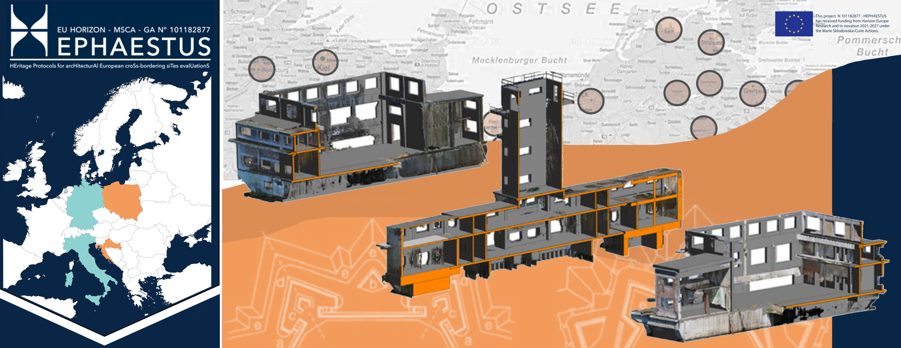
The growing focus on the green transition, coupled with the implementation of new construction and infrastructure projects, is raising important issues related to the encroachment on cultural heritage routes across Europe. Such encroachment poses significant challenges for the maintenance, planning and management of these routes. The HEPHAESTUS project (HEritage Protocols for ArcHitecturAl European cross-border SIte EvaluationS) aims to develop innovative digital information models and 3D databases to support the documentation and management of cultural heritage routes in European cross-border territories. The project will use the acquired data to improve sustainable planning and decision-making and enhance the preservation and stewardship of Europe’s architectural heritage. HEPHAESTUS will focus on military architecture in Italy, Germany, Poland and Croatia, using advanced digital technologies to examine its social and geopolitical implications. HEPHAESTUS is funded by the Marie Skłodowska-Curie Actions (MSCA) under Horizon 2023, Research and Innovation Staff Exchange (RISE), Proposal No. 101182877. The project runs for 48 months (2024–2028) and involves the following partners. Academic partners: Department of Architecture, University of Florence (Italy; coordinator: Prof. Sandro Parrinello); Department of Civil Engineering and Architecture, University of Pavia (Italy); Gdańsk University of Technology (Poland); Bochum University of Applied Sciences (Germany). Non-academic partners: Metaheritage (Italy); Fundacja to Get There (Poland); Urban Culture Institute (Poland); Tvrdava Kulture Šibenik (Croatia); Institute of Art History (Croatia).
3D Sebenico
The project involves the establishment of a research network for the development of practices for knowledge, conservation and enhancement of the Venetian fortified heritage in Dalmatia, in the Šibenik area.
Surveys conducted with digital technologies are the focus of the project by configuring scenarios of excellence in the development of a systematic practice of documenting the works. Field activities will focus, in addition to the best-known fortresses in Sibenik, on the defensive wall on the Oštrica peninsula near Grebaštica, a wall built by Venetian authorities during 1490 to defend the population from internal Ottoman incursions, to date included in the Croatian heritage registers (RST-0168-1964).
SMART BETHLEHEM
Sustainable Management And Renewal of Technology in the city of Bethlehem
AICS Cooperation Project
The project “SMART BETHLEHEM – Sustainable Management And Renewal of Technology in the city of Bethlehem “, co-financed by AICS – Italian Agency for Development Cooperation, wants to contribute to promoting sustainable and resilient urban and territorial development in Bethlehem area. The project, led by the Province of Pavia, provides for a partnership composed of local government entities, NGOs, universities, foundations, companies, and local associations.
The project includes four implementation dimensions: urban planning for the analysis of construction practices in the territory and the preparation of a Smart mobility plan in the historic center; the implementation of interventions on some buildings that will constitute the “smart” pole of the city; educational-training activities for the capacity building of local institutions; the construction of the city museum and the museum spread over the city of Bethlehem.
H2020-MSCA-RISE-2018 PROMETHEUS
PROtocols for information Models librariEs Tested on HEritage of Upper Kama Sites
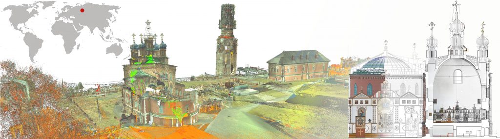
PROMETHEUS objective wants to implement an interdisciplinary action for the documentation and structuring of information about architectural heritage, boosting the training of researchers on the constructive and historical value of Cultural Heritage Routes. The research will develop innovative methodologies of digitisation of architecture with the integration of multidisciplinary data and Information Models, leading to specialised figures able to operate on heritage built assets. The definition of a “charta”, for the replicability of action, will be pursued with a practical action on the monuments present in Upper Kama route (Russia) as pilot case of study. The network of researchers from different sectors involved in the action favours/supports the cultural and thematic widening necessary to develop and show the skills that the market requires. The Italian expertise in digital survey of architectural heritage, the Spanish knowledge on building technology and census archives related to architecture, together with the historical and territorial planning knowledge provided by the Russian partner, will allow researchers to deal with professional companies that operate in the intervention fields of restoration projects and BIM Management. The research project will develop an information/cognitive 3D system, multidisciplinary and implementable, that represents the preparatory step for to the management, maintenance and valorisation of Cultural Heritage Routes over European committees and administrations. The system, in order to be widely applicable, will be Low cost and easy to replicate, and it will optimize an innovative channel of cooperation between researcher and professionals though the use of BIM Collaborative Protocols. Participants will exchange skills and knowledge that will allow them to progress in new methods of documentation and conservation, to strengthen collaborative research and to widen their career perspectives in European Heritage Preservation.
Visit the project web site >>Prometheus
3D Bethlehem – Management and control of urban growth for the development of heritage and improvement of life in the city of Bethlehem
 AICS Cooperation Project
International cooperation project, financed by AICS, which aims to promote the strengthening of the management and territorial governance system of the Municipality of Bethlehem through the transfer of cognitive experiences and methodological practices for the management and control of urban growth for development heritage and improving the quality of life in the city of Bethlehem. The project, which will implement a technological process of analyzing the urban form in order to plan the future city, has a duration of 3 years.
The Venetian fortifications in the eastern Mediterranean basin
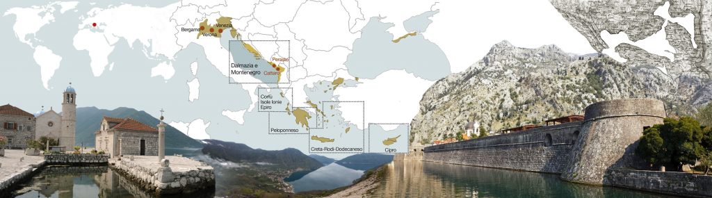
The eastern Mediterranean coast overlooking the Adriatic Sea is organized by an extraordinary sequence of fortified cities, villages, churches, and palaces that bear witness to the deep-rooted influence of the Serenissima in those territories. Among the many cities and fortresses built by Venice in these areas are those of Michele Sanmicheli, master of the Renaissance and Mannerism, commissioned by the “Senato Veneto” to oversee the fortresses of land and sea. The objective of the project is the development of a path of knowledge of Venetian works and Sanmicheli in the Eastern Mediterranean through 3D drawings and models for the development of an information database on the historical architectural heritage of Venetian fortresses.
The documentation of the Monumental Complex of the Alhambra in Granada
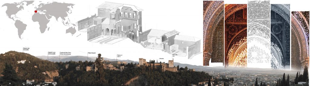 Today the Alhambra is a museum that hosts about three million visitors a year managed by a specific patronage. From a first meeting with the administration it emerged the need to create a database in order to preserve the historical memory of the complex and that can be configured as a useful tool for the management of the museum system-cultural heritage in the short, medium and long term . On this issue in January 2017, a collaboration between the SMlab Laboratory of the Universidad de Granada (responsible Prof. Antonio Gòmez-Blanco) and the Laboratory DAda Lab of the University of Pavia (responsible Prof. Sandro Parrinello) investigation phase that focused on the Generalife Palace. The research aims to respond to the growing need, in the cultural heritage sector, to organize information systems by structuring an integrated model that can be consulted. The documentation of the Palazzo del Generalife has provided for an integrated survey campaign laser scanner and SfM photogrammetric survey aimed at creating a 3D database from which to develop a three-dimensional model of the building. The census of constructive and decorative systems allowed to populate the database with functional descriptors to index the models that allow a semantic decomposition of the complex model for the analysis of its sub-elements. The objective of the research is the development of a structured information system on an integrated digital model descriptive of the entire area of the building, through the creation of a database for the management of architectural heritage that can become a useful tool and database for future maintenance interventions , restoration and enhancement of the complex through the possibility of using the model for different purposes: from the thematic readings, to digital elaborations such as web visualizations and 3D animations. Starting from the elaborated products, a virtual museum project was developed through the creation of an interactive visit to a portion of the Generalife building with the ultimate intention to create new opportunities and new tools for studying and understanding the built architectural heritage.
The survey of the Nativity Church mosaics in Bethlehem

The Constantinian mosaics of the Nativity Church in Bethlehem constitute one of the most important mosaic heritage in the world. Parallel to the restoration and unveiling of the mosaic, under the current level of walk of the church, the laboratory is developing drawing and survey techniques to optimize documentation practices for mosaic complexes, by the evaluation of automation processes and by analyzing the critical aspects of the interpretative process, that are functional to the redrawing of the ornamental apparatus.
3D Survey and Documentation for “Seismic assessment of natural stone masonry buildings in Basel”
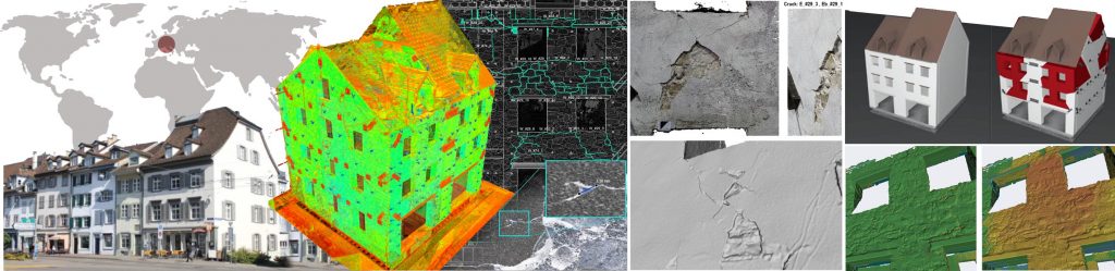
Earthquakes occurred in recent years have motivated numerous researches aimed at defining analysis strategies for the prevention of seismic risk, focusing on the documentation of the relative structural kinematics to coordinate conscious interventions on historic buildings. In-depth lines were conducted on the structural behavior of architectural aggregates, in particular within urban city centers. The increase in technical regulations on structural safety is now accompanied by digital survey and 3D modelling technologies capable of producing increasingly reliable drawings and performing extensive operations on building units and urban areas to the advantage of a homogeneous reading of the building heritage, identifying lability and deformations that could compromise the stability of structures.
The project “Seismic assessment of natural stone masonry buildings in Basel”, developed by University of Pavia and École Polytechnique Fédérale de Lausanne, on the monitoring of seismic effects that can be figured within European historical buildings, starting from the case study of the historic center of Basel. In particular, the joint activity of DAda Lab. Laboratory of Department of Civil Engineering and Architecture, and EUCENTRE, European Center for Training and Research in Earthquake Engineering, has allowed the application of digital survey procedures in the context of tests of seismic simulation for the study of historic city buildings.
The research developed highlights the potential and the optimization procedures of reality-based models expressed in their morphological configuration: the metric properties, as well as the configuration of the geometric model, represent a database of structural information that can be expressed through appropriate reading codes, belonging to to the expression of the 2D and 3D graphic language. The definition of the virtual image thus becomes the operation of genesis of the entire preventive process, as the primary action of defining databases, and the ultimate protocol for the derivation of graphic and technical products necessary as synthesis elements and for the dissemination of results.
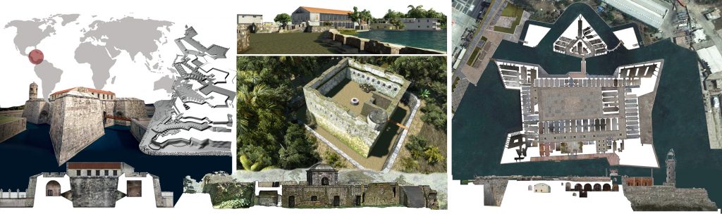
Analysis and survey systems for the study of military architectures with particular interest for modern military architecture, designed by Antonelli in the basin of Central America and North Africa. The research concerns the comparison of the typological characteristics of the fortified architecture, the study of the geometries that characterize the relationship between investigation and project in the definition of the defensive system and the production of dissemination systems for the promotion of monumental complexes.
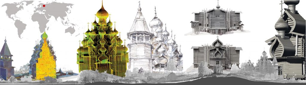
Wooden Architecture: traditional Karelian Timber Architecture and Landscape
 FP7-PEOPLE-2010-IRSES-Marie Curie Action
The wooden architecture of Karelia is recognized as an object of respect and interest on an international scale. The study days are aimed at the universities and institutions involved in the project and set as an objective the promotion of research activities undertaken in this country. The purpose of the operation is to encourage relations, not just cultural ones, between Italy, Finland, Karelia, by bringing in contact operators in this sector through a threading of meetings, of which the present represents one of the first opportunities. The scientific experiences gained on topics such as the recovery, rehabilitation and improvement of historical centers, with intensive research and analysis activities, have produced a know-how of great value today; in particular for the use of specific applications of new technologies, for monitoring and managing data useful for restoration, urban planning and management in sensitive areas, such as urban centers of historical and environmental interest.
In particular, the Karelian territory is configured as a dense area of elements that require high attention in order to increase the value of the territory itself and its human activities. The objective of a census of traditional wooden architecture and of the natural environment and landscape purposes is to determine not only the species and the appearance, but also the analysis of damage and conditions, to identify the factors of critical management. The census defines the landscape and environmental aspects, as well as the diagnostic framework of each context on the basis of its intrinsic characteristics, of possible non-traditional elements and to find a way to re-establish the correct structure of the place. We are able to identify and define intervention priorities. Innovative methods for surveying and geo-referencing data on architectural buildings allow us to acquire an exact knowledge of the status of the locations.
The survey of Masada site
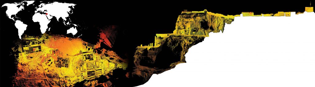 The Masada project was developed as a continuous research collaboration between the University of Pavia, the University of Florence and the Shenkar College of Design and Engineering in Tel Aviv. In addition to research aspects, the project also has educational features. The project consists of a proposal for digital documentation of the Masada cultural heritage sites. The project for digital documentation of Masada’s fortress in Israel is part of international research in the field of 3Ddigital documentation and mapping of important cultural and historical sites.
The Documentation of Al Nabi Musa Complex
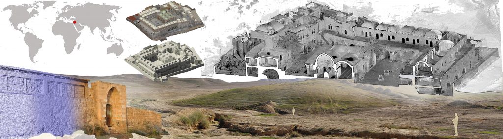 The Maqam al-Nabi Musa, which according to the Islamic faith represents the sacred place in which the prophet Moses was buried, is now the subject of a recovery and enhancement project promoted by the United Nations which has motivated a research project developed between 2015 and 2016 from the laboratory. Aim of the research, a methodological survey of documentation and analysis of the construction elements, aimed at both the diagnosis of the deterioration and the instability of the walls, and the promotion of the place as a cultural heritage.
The Survey activity in Jerusalem
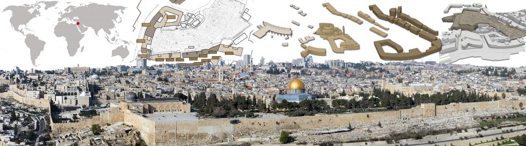 The city of Jerusalem presents itself as a very complex historical and urban reality. Its heterogeneity, which derives from the succession of historical events, is also repeated on the architectural and urban level. One of the most interesting neighborhoods is just outside the gate of Herod, in the urban area of East Jerusalem: Bab Azhar. The design and construction of these two roads derives from the development of an urban plan of the ’70s that was going to encourage trade outside the walls, creating an active and dynamic neighborhood that could push the population to live the city even outside the walls of the city. old City. This is the reason why today the Bab Azhar district is one of the busiest during the day: its proximity to the old city, in particular to the Muslim quarter, and its very varied commercial facilities have become important factors for the development and the growth of this place. In this territorial and cultural context, it has been proposed by the United Nations, in particular the section for the protection of the Palestinian Territories – U.N.D.P. – the P.U.R.E. program -Productivity and Urban Renewal Program in East Jerusalem- aimed at revitalizing the complex, so as to develop renewal proposals, thus re-launching the neighborhood’s economy.
The program developed was the starting point for this thesis that presents the documentation project of the main streets of the district of Bab Azhar, Sultan Sulemain Street and Salah Eddin Street, and of the monumental cemetery that is located in the area delimited by these roads, through integrated survey methods for the creation of interactive databases aimed at the management, use and understanding of the urban spaces in question. In particular, we focused on the use of virtual reality, which is aimed at a better understanding of space. Digital databases increasingly require the development of “narrative” systems for the use of information. In the digital space the user can interface with the structural elements of the database to develop critical analysis models.
The Documentation of the White Mosque of Al Jazzar in Acre
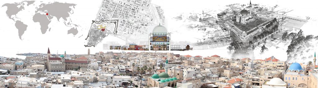 The study of Al-Jazzar white mosque, in San Giovanni of Acre in Israel (UNESCO world heritage since 2001), concerned the documentation of the conservation status, conducted through digital technologies, of the monumental complex. The survey campaign, conducted in 2017, has produced a survey of the entire monument, considered today one of the main Muslim religious complex, in terms of size and importance, in Holy Land. The aim of the research is the realization of drawings and models capable of transmitting the historical and material value of the different environments and construction apparatus, developing reading systems for diagnostic analyses on the state of conservation. The survey has made possible to propose useful considerations to decipher signs and masonry stratifications also related to elements and materials of reuse, such as the columns from nearby Roman sites and Crusader cisterns. The project, responsible prof. S. Parrinello, is governed by an agreement with DICAr Department of Civil Engineering and Architecture of University of Pavia for the application of survey methodologies functional to the creation of a three-dimensional database for the documentation of the site, usable as a knowledge base for the development and archiving of structural and conservative diagnostic observations. The research highlights the potential of digital survey to plan recovery interventions and define guidelines for consolidation, functional rehabilitation and enhancement of historic environments in Al-Jazzar complex.