
National Research
The Laboratory carries out numerous researches on the national territory, among these the main ones are:
BROWNFIELD DIGITAL TWIN. Experimental research project for the generation of reality-based 3D information models of existing ENI plants
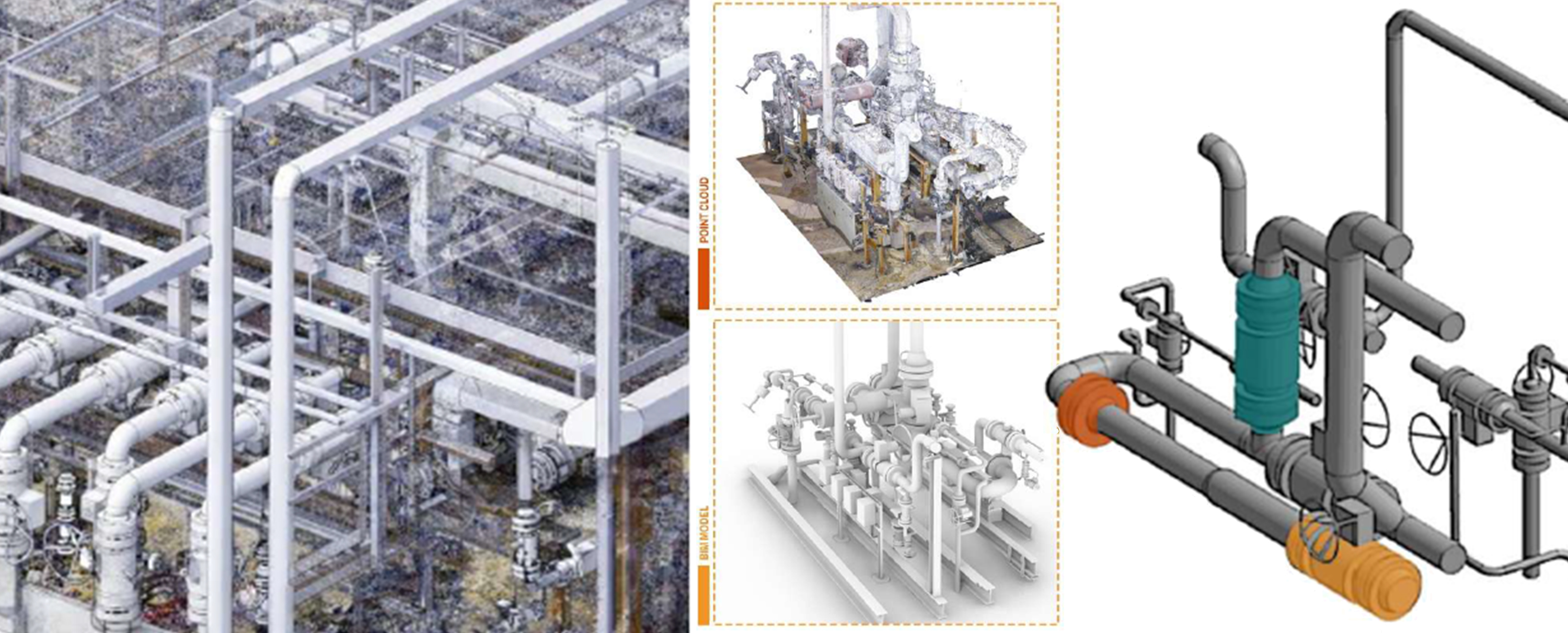
The research project, developed in collaboration with ENI, aims to define a rigorous protocol for creating a Digital Twin from scan data. The process begins by organizing the geometric entropy of the point cloud and recoding the repetitive nature of plant components within a parametric framework, in order to effectively meet maintenance needs and support decommissioning planning. The research is structured into two complementary work packages. The first focuses on data control, verification, and segmentation, ensuring the quality and reliability of the point cloud as the foundation of the modeling process. The second concerns the development of the information system through parametric modeling, which interprets structural and plant systems as sets of recurring components and system families. In this way, seriality is not treated as simple repetition, but rather as a generative rule, enabling a workflow that is both replicable and adaptable to other similar offshore facilities. The resulting information model makes it possible to document not only form, but also time and information.
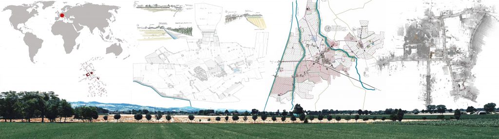
Medici villas and gardens. A network connection dedicated to sustainable mobility
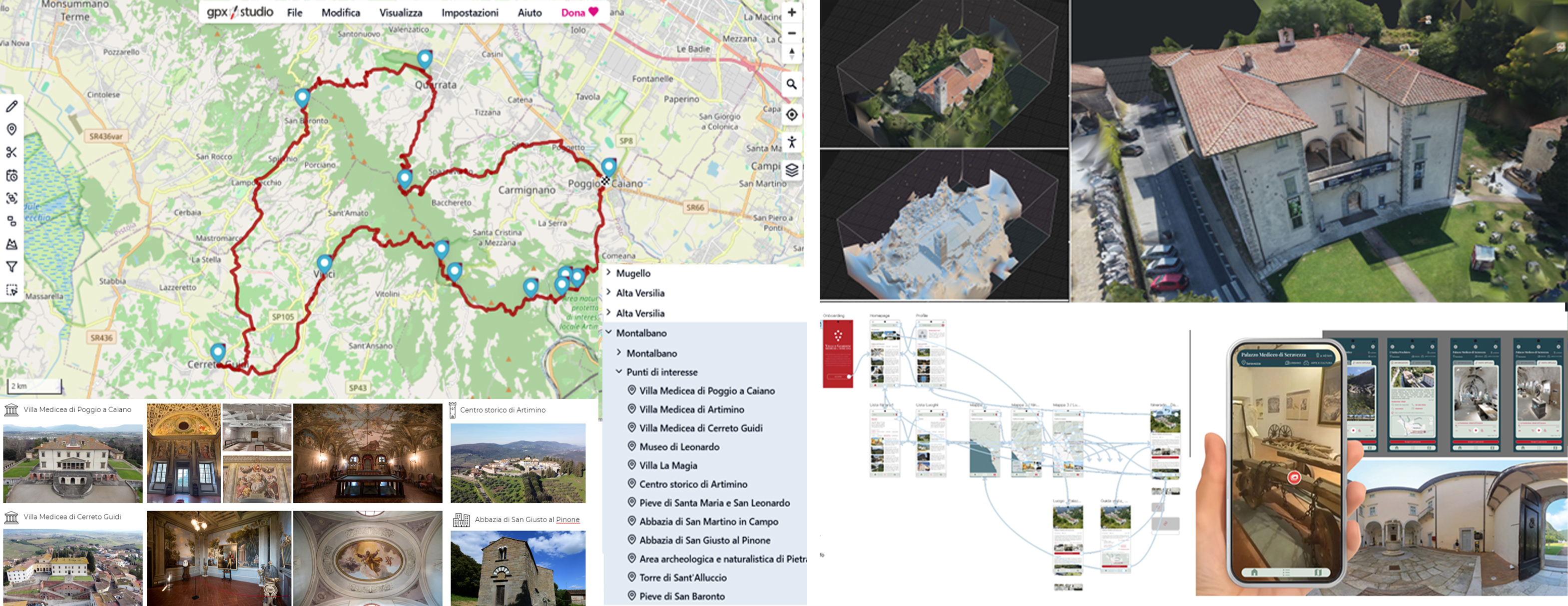
The project involves the organisation of a methodological protocol aimed at producing an accurate database of documentation and digital systems for the cultural promotion of the widespread heritage of the ‘Medici Villas and Gardens in Tuscany’, which has been included in the UNESCO World Cultural and Natural Heritage List since 2013.
The main mission is to promote tourism, sports and cultural activities in these historic sites by providing a reliable 3D information system capable of connecting the extent and complexity of the Tuscan landscape with the architectural complexes of the cultural landscape surrounding the villas, proposing the production of remote and on-site systems for museumisation and digital enjoyment for visitors. The actions of this proposal will be implemented using advanced digital technologies with high metric and colorimetric reliability, through which new forms of cultural communication will be designed with digital storytelling systems. Specifically, methodologies for analysing and interpreting the morphological and geometric characteristics of the territorial system will be developed to structure a path dedicated to the knowledge and protection of the Garfagnana Heritage. Through data acquisition and processing, scientifically valid products will be created for the establishment of a digital archive of the architectural and landscape heritage of the Villas and Gardens, which will be used as a fundamental support for the conservation, preservation and promotion of this heritage.
DIGITAL-VISIO. Digitisation of the Price List for Works in Tuscany
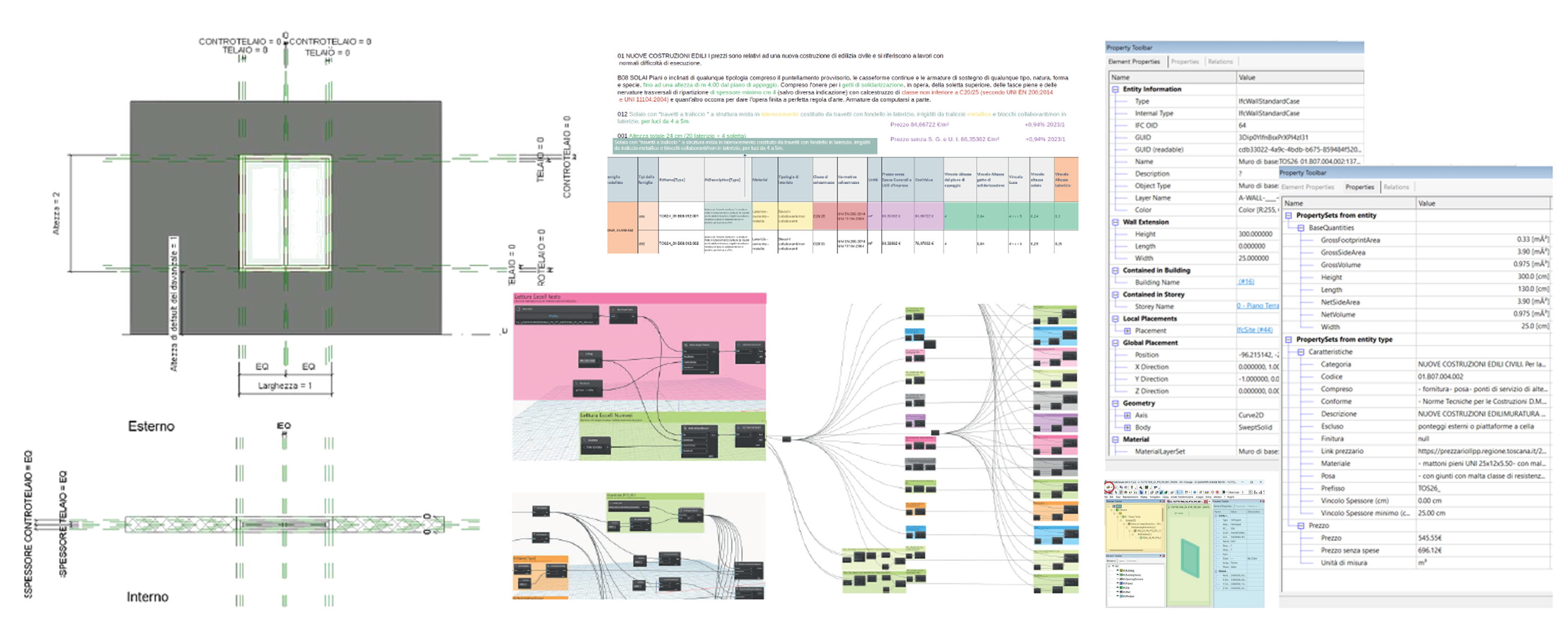
DIGITAL-VISIO is an experimental research project promoted by the Tuscany Region with the University of Florence and the University of Pavia, aimed at digitising the Public Works Price List and translating it into a BIM library and operational guidelines for information production. The goal is to make the contents of the price list more structured, comparable and verifiable, supporting more transparent and consistent design and management processes throughout the life cycle of the work. The project adopts an interoperability-oriented approach: item information is reorganised into descriptive fields that can be read by modelling software, so as to directly link technical characteristics to elements of the digital model. The library is a reference standard and not just a catalogue to be imported, while the guidelines define criteria and delivery methods to ensure data quality and traceability. In this context, DIGITAL-VISIO promotes the use of openBIM formats, in particular IFC, as a basis for the exchange and verification of models between different tools and actors, favouring greater portability of information and reducing dependence on proprietary solutions.
DEMETRA_Sistema DEMo di simulazionE e Training viRtuale per l’operatore di Agroindustria primaria
Training activities in a simulated environment, exploiting platforms based on virtual reality and mechatronic systems, can be considered a well-established State of Art in the transport sector (i.e. aerospace, automotive and nautical). In primary agri-industry, on the contrary, simulator solutions are in their beginnings, mainly focused on the study of tractor dynamics or the control of operating machines according to the logic of precision agriculture. The possibility of using a training platform available throughout the year (being developed in a virtual environment) would free the learning path of an agricultural activity from the seasonality associated with it. The use of simulation systems for training and practice of the agricultural operator does not currently find application in the agro-industrial environment, although some solutions (e.g. vineyard pruning training) have been proposed in the research activities of international groups. These solutions, however, provide
for the movement of the operator in the virtual environment by joysticks and do not guarantee the
perception of full immersion, penalizing the verisimilitude of the training activity.
DEMETRA aims to develop a Proof of Concept (PoC) of a platform for training of agricultural operators in a virtual environment, based on human-in-the-loop techniques and innovative in terms of immersiveness: the operator can actually walk on a multidirectional treadmill and the mapping of his/her movement, obtained by IMU sensors and a 3D camera system, allows him/her to control the movement within the virtual space in a synchronous and coherent way. For these reasons the selected project team has multidisciplinary skills in mechatronics and 3D reconstruction of virtual environments.
The PoC also aims to demonstrate the possibility for the operator to interact in agricultural scenarios where the form of farming is more complex than the one related to vineyard, which can basically be considered a 2D environment. Most of other fruit trees are cultivated allowing for the development of the plant even in the inter-row space, requiring a more complex interaction between operator and digital model, in which the third dimension plays an essential role.
GO-IN! diGital platfOrm for INner areas. Interactive virtual platforms for the enhancement of fragile contexts and their cultural heritage
GO-IN! intends to test virtual fruition systems applied to the cultural and landscape heritage of small historical centres in fragile internal areas. With the aim of protecting and enhancing these settlements, today at risk of depopulation, abandonment, degradation and disappearance of historical memory, GO-IN! proposes a replicable protocol for the construction of digital twins of such areas. Digital documentation, analysis of the state of conservation of buildings, census of services and territorial resources, geological survey and assessment of hydrogeological and geomorphological vulnerability will therefore be developed on an initial sample area within the small historic centre of Stigliano (MT) in Basilicata.
The information collected will flow into 3D models accessible through a 3D GIS, which can be consulted and implemented over time by the technical operators, for the programmatic management of the interventions; and an interactive virtual platform usable by citizens and more generally by anyone who wants to discover the village, interacting with the digital space, with the virtual contents and with other users.
DORIAN_sustainable resilient safe enviroment

The Department of Civil Engineering and Architecture of the University of Pavia (DICAr) results as one of 180 Italian departments selected by the Ministry of University and Research (MIUR) for the period 2023-2027 as part of the “Departments of Excellence” initiative, which rewards departments that stand out for the quality of research they produce and funds specific development projects.
The DAda-LAB laboratory falls within the research groups, present within DICAr, that will develop research activities related to the DORIAN project. This project aims to improve the quality of the Department by expanding the current excellence and expertise of the different research groups, adopting a common project methodology throughout DiCAr. The goal is to create a synergy between reality and its digital simulation, addressing with a unified and trans-disciplinary approach the current issues and global challenges for the development of Sustainable Development Goals 6, 7, 9, 11, 12, 13 and 15 proposed by the UN Agenda 2030.
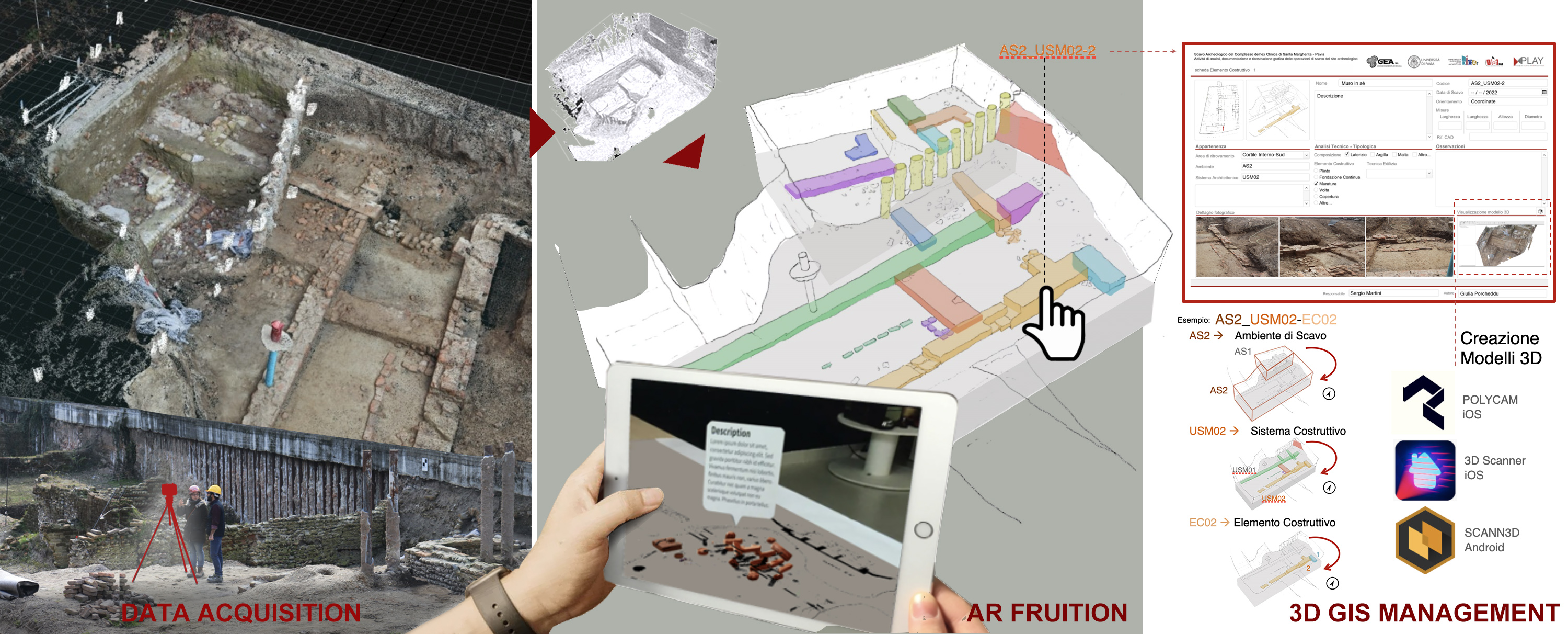
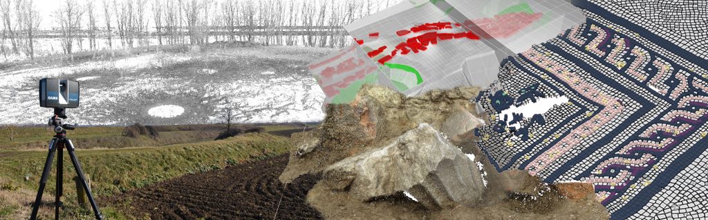
Survey and 3D GIS of the archaeological excavations in the complex of the Santa Margherita clinic in Pavia
The project involves the development of a methodology for the organization of data concerning archaeological excavations in emergency. From the production of 3D models on the single excavation actions to the compilation of catalog cards on the different US, the aim is to build a digital database in which to insert the stories of the archaeological activities carried out in the former clinic Santa Margherita of Pavia. Graphic elaborations and digital databases are oriented to constitute a three-dimensional map useful to show what has been found in a logic of overall reading of the area involved in the research. The 3D GIS platform can be configured as a real booklet of excavation in which to collect information that will then be directly connected to the 3D models.
Documentation and 3D printing of the bas-reliefs of Donatello’s Pulpit in Prato
On the occasion of the exhibition “Donatello and the Renaissance” some of the original panels of Donatello’s Pulpit have been removed from the Cathedral Museum of Prato. The Laboratory has organized an accurate methodological protocol aimed at documenting and prototyping, by means of 3D printing, to temporarily replace the missing panels. The documentation campaign was carried out by producing a detailed database of the architectural and sculptural apparatus of the pulpit, including not only the rooms of the museum but also portions of the Cathedral. The facade was redesigned at the same time as all the rooms that characterize the path of the sacred belt during the rite of ostension.
Digital reconstructions and exhibition itineraries for the story, between archeology and papyri, of the 20th century excavations in Arsinoe
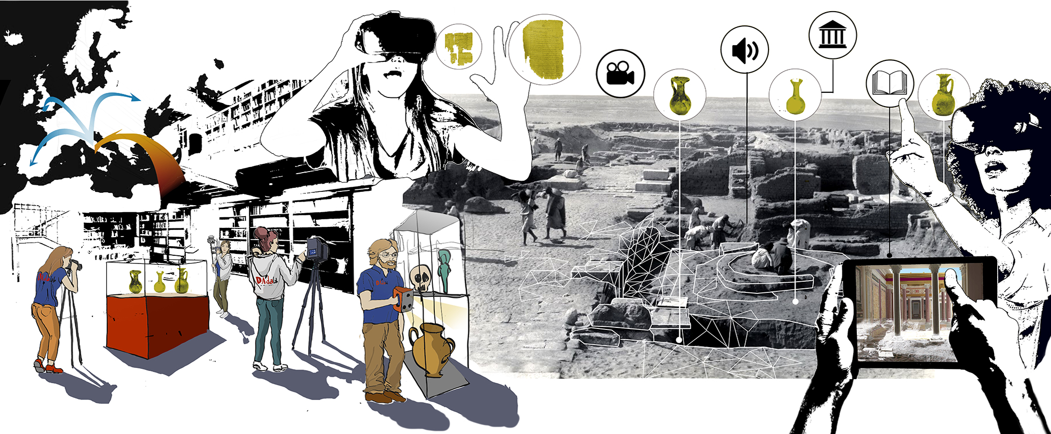
The archaeological collection of the Papyrological Institute “G. Vitelli” brings together the finds received in Florence from the excavation campaigns conducted by the Institute in Egypt between 1964 and 1965 in Arsinoe (capital of the nomos Arsinoites, now Faiyûm). During the mission, directed by Sergio Bosticco with the collaboration of Manfredo Manfredi, some archaeological finds were found that date back to the Ptolemaic and Roman age (III BC-II AD). The research promotes the digital reconstruction of the excavation and the construction of a virtual environment to be able to visit again the archaeological area now buried under the construction of the modern city. The production of three-dimensional models, to support the analyzes and interpretations on the reconstruction of this excavation, is aimed at producing a digital exhibition designed to enhance the collection of the Institute and recover an important fragment of history.
Digital documentation and development of the HBIM model of the Castiglioni Brugnatelli College in Pavia
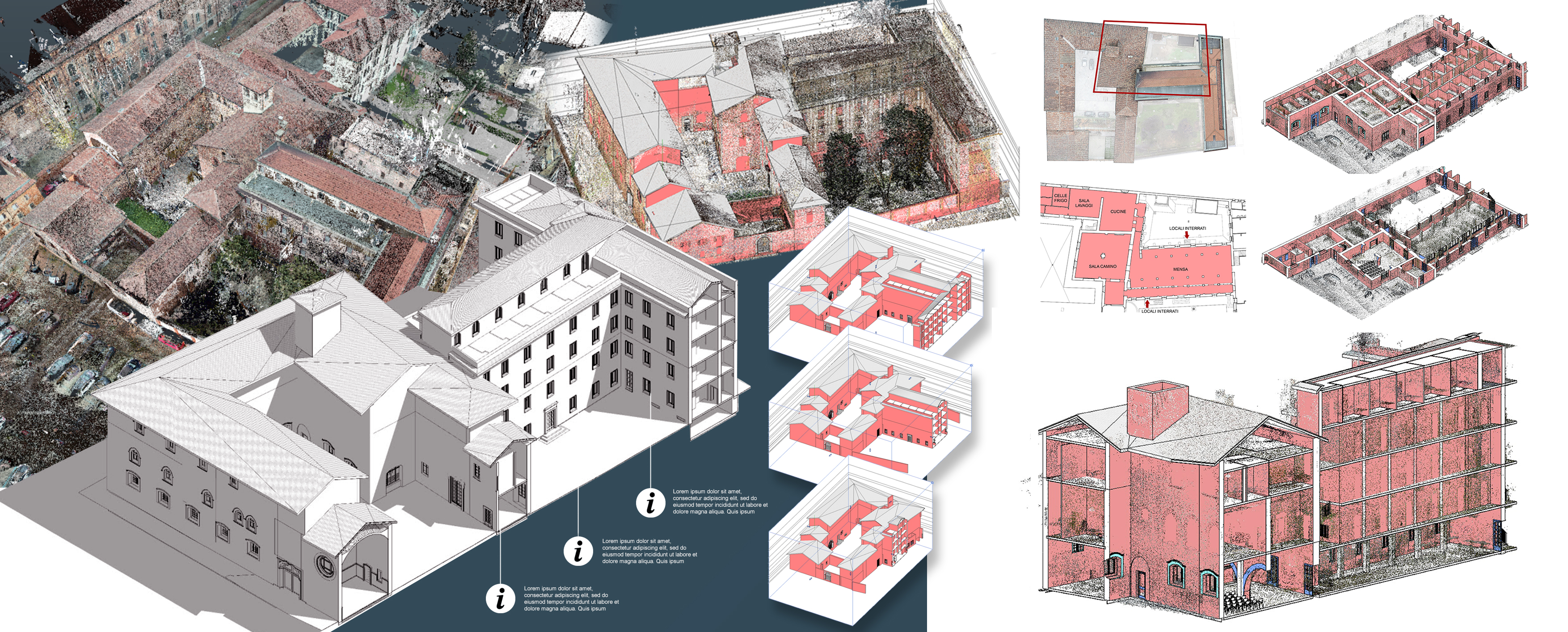
The research project, conducted by the DAda-LAB and PLAY laboratories of the University of Pavia, is part of a program of actions aimed at documentation for the programmatic management of the interventions to be carried out on the university buildings of Pavia. Specifically, the experimental action on the Castiglioni Brugnatelli College involved the production of a 3D digital database and a parametric model, created with an integrated digital acquisition process of the “Scan to BIM” type, from which it was possible to produce digital drawings. Metrically reliable 2D and 3D, both of the internal and external environments of the complex. Thanks to these searchable and constantly updated digital media, it will be possible to develop proposals for maintenance and improvement measures consistent with the image and importance of the building complex.
Digital documentation and analysis of the wall structures of the Castle of Cigognola
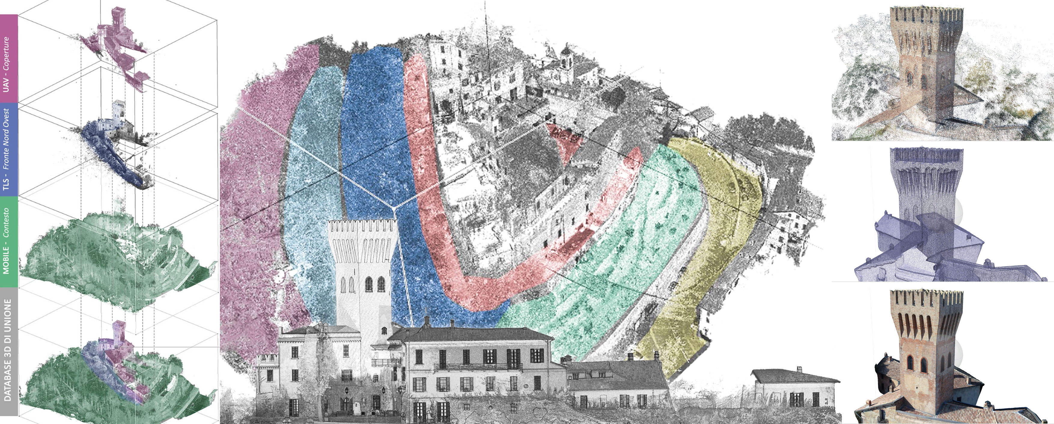
The documentation and morpho-material survey activities of the Castle of Cigognola were carried out on the indication of the Superintendence of Milan and the owners of the Castle on the north-west portion of the complex. The documentation campaign was conducted on the external surfaces of the walls. Survey activities were carried out using Terrestrial Laser Scanner, LIDAR KAARTA Mobile, photographic shooting with 3D Eye and UAV instrumentation and photographic shooting from the ground for photogrammetry and diagnostic evaluations. The drawings and analyzes produced by the survey represent a set of 2D two-dimensional drawings, readings of critical issues through elevation maps and reading of alterations with atlases of degradation to provide the client with a product suitable for the development of restoration and intervention projects.
Documentation of the architectural elements and materic survey of the complex of the Central Palace of University of Pavia
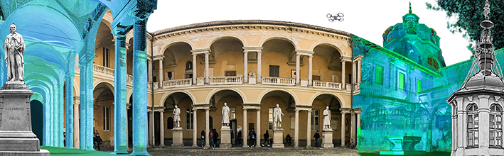
The research project concerns the documentation of the external fronts, courtyards and environments of the Central Cross Hall of the ancient San Matteo Hospital, of the Central University building, in the heart of the city of Pavia. It is carried out jointly with PLAY laboratory of University of Pavia. The survey campaign has been conducted with laser scanner equipment and with photogrammetric shooting techniques; it involves the use of drones for monitoring the most higher roofs and environments of the complex in order to produce a preliminary analysis for the management of conservation and maintenance operations. Particular attention is paid to the study of the color of the pictorial surfaces of the fronts of the complex.
Archeology 3.0_ Analysis activity, documentation and graphic restitution of the archaeological excavation of Bedriacum in Calvatone (CR)
The research, conducted by DAda LAB Laboratory in collaboration with University of Milan, Municipality of Calvatone, “Gina and Ferruccio Del Re Foundation” of Calvatone, “Anemos” Association, is co-financed by Regione Lombardia, through the call for tenders for the promotion of archaeological area enhancement projects for sites registered or candidated for the UNESCO list and cultural itineraries in Lombardy. The activities concern the development of a three-dimensional database able to describe the archaeological site of Calvatone.
Through surveying and redrawing operations conducted during the excavation campaigns over the last 20 years, a cognitive picture of the excavation actions is determined, which will be accessible through multimedia information systems.
Three-dimensional models will support stratigraphic analysis for the development of reconstructions of hypothetical models that will allow thematic maps to be updated, and information tools can be created to promote the archaeological heritage through a Visitor Center setted in Calvatone.
The documentation of the Verona Military Architectures
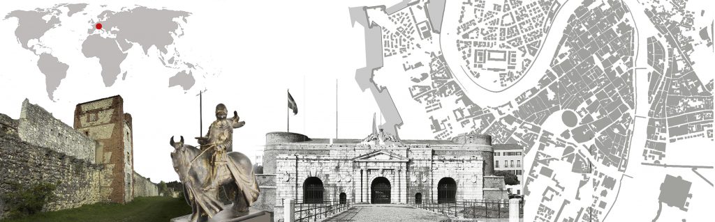 In the urban area of Verona, monumental works are still visible today, forming a repertoire of almost 2,000 years of history of fortification art. Even today the remains of the Roman fortified city remain, the perimeter of the walled city of Scaligera, the bastion structure of the Venetian fortress, the grandiose layout of the Hapsburg stronghold, the cornerstone of the Quadrilatero. The urban city wall, in its final structure, has a development of over 9 kilometers and occupies almost 100 hectares with its works: towers, washers, bastions, ditches, embankments. The defensive system of Verona is an impressive complex consisting of several elements arranged between hills and plains around the city of Verona, constituting not only an extraordinary typological catalog of military architecture and its development but also an urban and now almost unique landscape world. This stratified defensive system is one of the key points on which the UNESCO declaration of the city is based, expressing an international historical and cultural value waiting to be fully rediscovered and enhanced. The research, launched in 2016 by a collaboration with the Porta Palio Mutual Aid Society, is now governed by an agreement with the Municipality of Verona and is still ongoing.
Metric analysis of the Clock Tower in Pavia
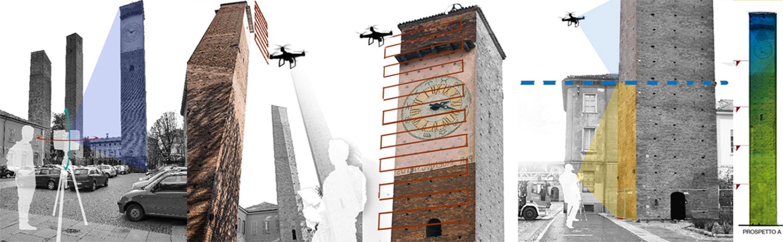
The research concerns the definition of the most appropriate methodologies for the documentation of metric data of the Clock Tower of Pavia. Through the use of drones and laser scanners, it is possible to define a reliable metric database to obtain drawings and models useful for the interpretation of the actual state of the historic monument.
Fast survey for After Disaster digital documentation: churches damaged by earthquake in Abruzzo.
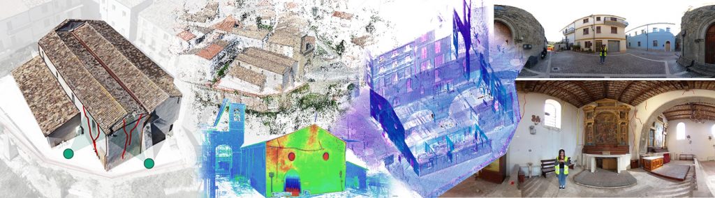
The production of a 360° documentation database of architectural complexes, from the metric and photographic data to the deformation analysis, is preparatory to the insertion of such information on immersive Reality Augmented platforms, where the fruition actions allowed by the users’ interface are communicated to the public, in exploration and training mode, through informative tours of remote access.
The study of urban centers in the Oltrepò Pavese plain
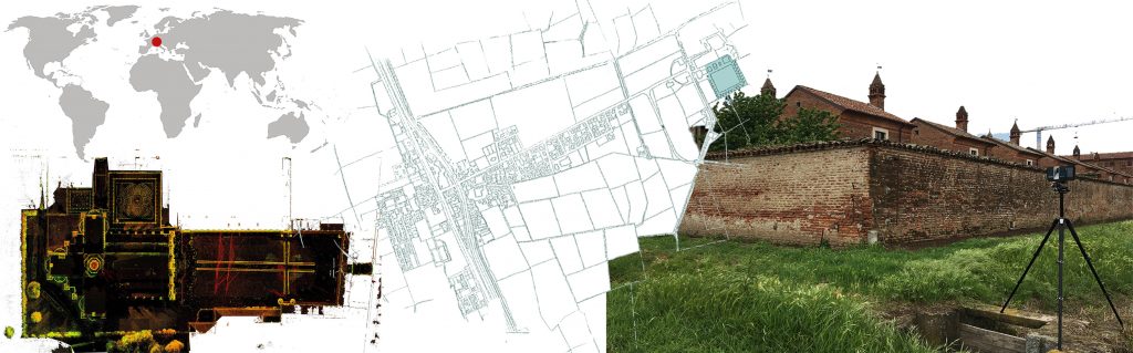
 The project concerns the development of a system of analysis for the understanding and representation of the landscape of the plains in the Oltrepò Pavese, in order to preserve and conserve its historical landscape heritage. The cataloging of the territory and its constituent elements becomes a tool to trigger a network between administrations, local authorities and universities in order to promote cultural traditions and the value of the territory. Since 2013, documentation actions are in progress aimed at protecting and safeguarding the memory of this landscape and cultural system.
The documentation of Villa Adriana
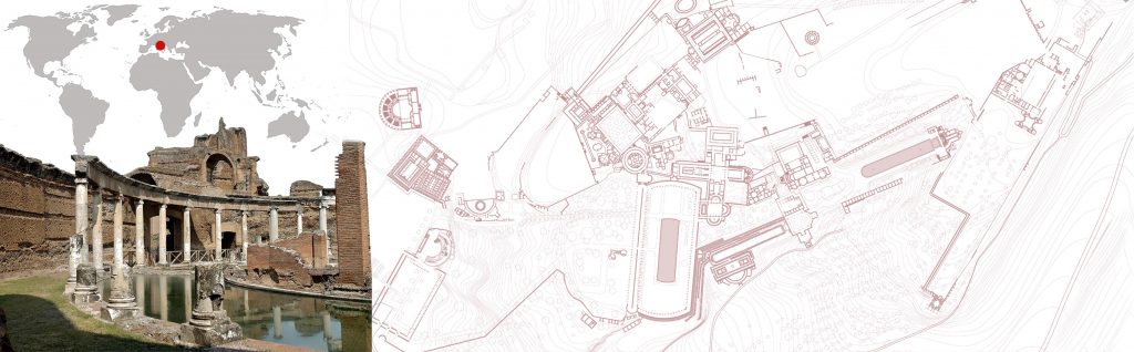 The multi-year survey project aims to provide the Soprintendenza with a three-dimensional database of the Villa’s rooms, capable of describing the state of the places both in terms of the conditions of the walls and of the relationships between architecture and landscape. Villa Adriana represents the highest expression of imperial architecture, combining spaces linked both to political needs and to recreational and leisure activities in a complex with urban articulation immersed in the harmony of a landscape where nature permeates the structures with pools, games and water and visual cones that open up to Rome. The documentation and survey activities of the ruins, organized in documentation campaigns, have produced today a partial database of the Villa made up of high density point clouds from which 3D models are processed on which to study the morphological systems, construction details and walls to identify the architectural relationships between the elements and the landscape systems, from the large scale to the single wall detail.
Villa Adriana is one of the most complex Italian archaeological sites, this research intends to develop a documentary apparatus capable of describing the state of the places, explaining techniques and constructive systems to simplify thematic readings that can promote knowledge about heritage. At the same time the research develops a reflection on the quality of the models and drawings for the description of the ruins in their current state and through virtual reconstruction procedures.
The study of the Eremitic Architecture and the survey of the Certosa di Pavia and the Certosa del Galluzzo
 Research undertaken since 2005 with the survey and documentation of the main hermit complexes of Tuscany such as Monte Senario, Vallombrosa, Camaldoli and La Verna (in progress) and continued with the documentation of complex hermitages in Pavia with the Hermitage of Sant’Alberto di Butrio .The documentation of the Certosa di Pavia and the Certosa del Galluzzo, started in 2014 and still in progress, is aimed at compiling a database of the two monumental complexes to extrapolate a cognitive framework for the whole complex and for the individual cells, in order to to define informative models useful for the enhancement and management of these complexes.
Documentation and analysis activities for the Uffizi restoration site
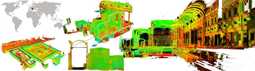 Since 2010, numerous surveying and documentation activities have been carried out at the Cantiere dei Grandi Uffizi, developing activities and experiences of supporting surveys for technicians and for specialists active in construction works. These activities have been the subject of agreements between the Department and the Superintendent offering to scientific research, a series of important occasions to test and develop innovative 3D digital survey methodologies more specifically dedicated to structural architecture monitoring.